Mississinewa Lake was designed and built by the Louisville District of
the U. S. Army Corps of Engineers.As
part of the 9,00 acres of land managed for wildlife are two heavily used State
Recreation Areas, Miami SRA and Frances Slocum SRA.The campground is located in the Miami SRA.
Through the ages, the rushing waters of what is now known as the
“Mississinewa” (Miami name Mischis-in-wah…water on a slope) washed away the
soft limestone of the riverbank, creating a number of pillar-like formations
known as “Cliffs of the Seven Pillars.”
On November 2, 1778 Frances Slocum, at the age of 5, was taken from her
Quaker home at Wilkes-Barre, PA, by the Delaware, who named her
“We-let-a-wah.”She grew up to be so
strong that her name was later changed to “Ma-con-a-quah” – Little Bear
Woman.She married Shepoconnah, War
Chief of the Miami Tribe, and when he later became deaf and resigned as chief,
they established a trading post called “Deaf Man’s Village” about nine miles
from Peru on the Mississinewa River.
Deaf Man died in 1833 and Frances built a two room cabin across the
road, near the burial place of her husband and two small sons.Her identification was not learned until
September of 1837 when her brother , Issac Slocum, identified her by a scar on
her left hand.As a result she was no
longereligible as an Indian, for the
pension made possible by the Treaty of 1826 since she was a “white woman.”In 1838 her two daughters were given 640
acres of land including their mother’s original homesite. Francis Slocum and
her family were permitted to stay in Indiana because John Quincy Adams
eloquently defended her case in Congress.She died on March 9, 1847 and was buried next to her husband and two
small sons in the cemetery next to her cabin.In May 1900 that area was named the Frances Slocum Cemetery.
We left home on Thursday, September 20th and headed West to Turkey Run State Park, west of Indianapolis. After spending a warm night in one of Indiana's most beautiful state parks, we head up US 41 toward northern Indiana. This route was so much better than taking the interstate. We traveled around Chicago to Winnetka, IL. This was a side trip for an elementary school tour and dinner (Class of '64) and my 50th high school reunion (Class of '68). We were allowed to camp for two nights at the park district athletic complex.
During our stay in Winnetka, we discovered our fridge was at 49 degrees. The fridge code showed no voltage. Our batteries were on year 5 so we rolled the dice and lost. On Sunday we drove over 800 miles into western Nebraska, to position ourselves to get into Rocky Mountain Four Wheel Camper early Monday Morning 9/24. We arrived at 9:30 am and departed with two new AGM batteries at 11am. Great job by the FWC crew and a big life saver. We would discover additional problems well into our trip and more about that later.
Our trip covered over 4,500 miles, 5 National Monuments, 3 National Parks, 1 National Historic site, 4 State Parks, 1 National Recreation Area, 3 State Recreation Areas (Reservoirs), and numerous other points of interest.
Colorado National Monument
Bears Ears National Monument
Grand Staircase - Escalante National Monument
Natural Bridge NationalMonument
Scotts Bluff National Monument
Arches National Park
Canyonlands National Park
Capitol Reef National Park
Turkey Run State Park, Indiana (camping)
Dead Horse Point State Park, Utah (camping)
Gooseneck State Park, Utah (camping)
Prairie Rose State Park, Iowa (Camping)
Chimney Rock National Historic Site
Glen Canyon National Recreation Area (Lake Powell) (Camping)
Horse Tooth Reservoir, Fort Collins, CO (Camping)
Lake McConaughy State Recreation Area, Nebraska (Camping)
Lake Minatare State Recreation Area, Nebraska (Camping)
9/24-9/25
Our first stop was Colorado National Monument. Impressive sandstone monoliths, the remnants of canyon walls, were created by millions of years of erosion. Established May 24, 1911, Colorado National Monument preserves 32 square miles of grande landscapes within the plateau and red rock canyon country. We had several hours to visit several viewing places as we drove the nineteen miles from Grand Junction, CO to the campground in Fruita, CO. We visited the visitors center and later watched the full Harvest (Fruit) Moon rise above the buttes. In the morning, at sunrise, I was able to get a picture of the moon setting above our camper.
Traveling through the Rocky's
Harvest (Fruit) Moon setting over Colorado NM and "Mountain MaMa"
9/25-9/27
We headed for Arches National Park. We spent the afternoon driving around Arches and taking short hikes to some of the arches viewing points. This didn't do justice to the park, but we were able to see a lot. We camped for two nights at Dead Horse Point State Park. This was a beautiful campground. We had a beautiful view of the Henry Mountains and two beautiful sunsets. Dead Horse Point is a bend in the Colorado River. The views were amazing. Arches is in the heart of canyon country. The parks distinctive landscape is punctuated by rocky ridges, canyons, fins, towers, monoliths, pinnacles, and more than 2000 arches.
Delicate Arch
Deadhorse Point State Park
The Shoe
Dead Horse Point State Park - Colorado River
Dead Horse Point
The next day we drove to Canyonlands and spent most of the day exploring the Island in the Sky portion of Canyonlands. We drove all areas of the park and took some short hikes. Canyonlands is also the start of the Shafer Trail which leads down into the canyon and connects with the White Rim Trail. We discussed taking Shafer Trail down and back up, but it was late in the day and we made a decision to return to Dead Horse Point to do some more exploring. This was a decision I later regretted, as we would run a couple of other trails. Canyonlands is rugged and spectacular country. The area is mostly high desert characterized by sandstone, shale and limestone formations. There is an array of striking geological landscapes composed of canyons, mesas, buttes, and spires formed from the varying sedimentary rock formations. The confluence of the Colorado and Green Rivers lies within the park.
Henry Mountains
9/27-9/28
We
drove into the town of Moab a couple of times. We stocked up with
supplies and headed South to visit the Needles part of Canyonlands.
We
saw the Wilson Arch as we were leaving the Island in the Sky.
We took
the scenic drive and visited the visitors center. Afterwards, we headed
in the direction of Capitol Reef. We crossed the Colorado River at
Hite, UT We stopped to look at our Utah Benchmark and plan the next 2
nights.
Camped on the rim of Goose Neck State Park above the San Juan River. Other campers were a half mile away along the rim. Beautiful sunset.
Breakfast at the Hat Rock Cafe in Mexican Hat, UT
Mexican Hat
From Mexican Hat we drove to the Valley of the God's and drove the 17 mile wash board road.
After completing the drive through the Valley of the God's we took the Moki Dugway switchbacks up to Cedar Mesa and drove to Natural Bridge Natural Monument. We drove through portions of Bears Ears National Monument.
Moki Dugway Switchbacks from Monument Valley up to Cedar Mesa
We decided to stay at Glen Canyon National Recreation Area in
Bullfrog, UT on Lake Powell. The temperatures were over 90, but the
breeze and some shade made things more bearable. Good thing for dry
heat. Lake Powell looked like it was over 20 feet below normal water
level.
We decided to stay at Glen Canyon National Recreation Area in
Bullfrog, UT on Lake Powell. The temperatures were over 90, but the
breeze and some shade made things more bearable. Good thing for dry
heat. Lake Powell looked like it was over 20 feet below normal water
level.
It was here that we discovered more problems with our voltage. We had perfect sunny skies and one day I set up the 80W portable solar panel and by 7pm the controller said 13.3. As soon as I unplugged the portable panel, the controller dropped to 12.5 and tow hours later it was down to 12.3. The fridge continued to work. As we moved on to Capitol Reef we were waking up to the controller showing numbers of 11.9 and each day a little lower. More on this story later.
9/30 - 10/2
We left Glen Canyon and took the Burr Trail and Burr Trail Switchbacks, driving along and through the Water Pocket Fold. The drive took us through The lower section of Capitol Reef National Park, Grand Staircase - Escalante National Monument and Long Canyon, to Boulder, UT and the Capitol Reef visitor center. We arrived at Capitol Reef around noon.
Burr Trail through the Water Pocket Fold and the Burr Trail Switchbacks
Burr Trail through Grand Staircase - Escalante NM and Long Canyon and along Rattlesnake Bench
We picked apples and purchase a fresh baked Strawberry-Rubarb pie and a Berry Fruit pie. They were awesome.
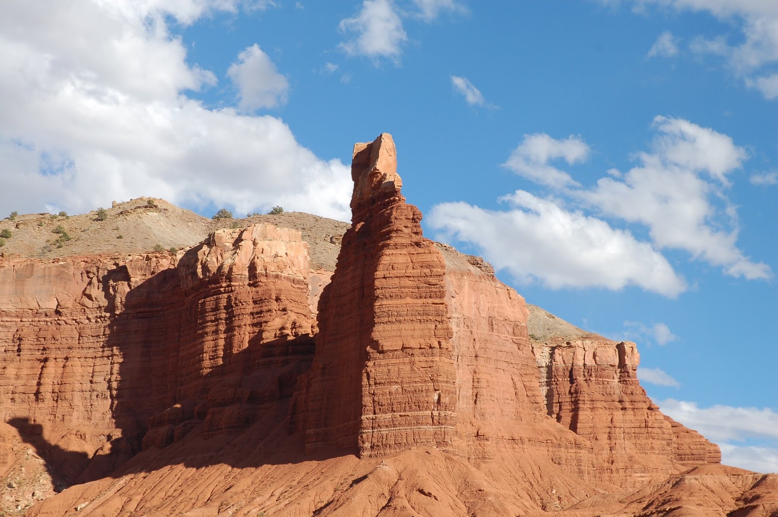
Capitol Reef is a geology wonderland. We enjoyed this park the most.
Capitol Dome
Chimney Rock
The Castle
We were at a crossroads. We knew we had some type of charging problem. We had 3 nights booked at Capitol Reef and had decided earlier to leave on the third day for Telluride, CO. I wanted to get in some flyfishing and had a 5 day license. October 3rd was Susan's birthday and i wanted to take her out to a special evening in Telluride. As we watched our lack of charging, we became aware that Tropical Storm Rosa had moved through Baja and was going to dump rain on Arizona, Utah, and SW Colorado. Capitol Reef was going to get over 2" and their total rainfall is usually 8"-10" a year. The park was going to close the canyon areas down in anticipation of flashing flooding. The decision was made to leave and head home, back through Denver. I contacted Rocky Mountain FWC and told them the problem and gave them an anticipated arrival time. As soon as we arrived they ran a complete system check and discovered the solar controller had given up. They replaced it and everything was working as it should. From Denver we headed up the road to Fort Collins and camped at Horsetooth SRA, a beautiful site. Susan wanted to go on a tour of Anheiser-Busch. We showed up for the 11am tour only to find out they just switched to their fall schedule, no tours on Tuesdays or Wednesdays. We had lunch and toured the grounds. We them headed North into Laramie, WY and into Nebraska, heading home.
As we headed East we made two last stops. We stopped at Scotts Bluff National Monument. This was the site of a Pony Express stop and part of the Oregon Trial.
The formation served as a landmark along the Oregon Trail, the Csalifornia Trail, and the Mormon Trail during the mid-19th century. The trails ran along the north side of the rock.