Tuesday, June 14, 2016

2016 - Wisconsin & Michigan's Upper Peninsula - Part 3


June 10th
Good things eventually come to an end and it was time to say goodbye to Pictured Rocks National Lakeshore.  Next time we will take the sunset cruise so we can see the beautiful Sandstone Cliffs.  We drove back into Grand Marais and stopped at the Breakwall Bakery & CafĂ©.  I had the Loggers breakfast, eggs and pancakes and Susan had their Blueberry muffin and a bowl of oatmeal.  Next to the restaurant was a building resembling a “Pickle Barrel”.  It is on the National Historic Register of Places.  It was built as a summer home for a cartoonist for the Chicago Tribune and then moved to Grand Marais, from its original location on Grand Sable Lake.


We had time to kill as the drive to Tahquamenon SP was only and hour and a half.  We decided to drive 
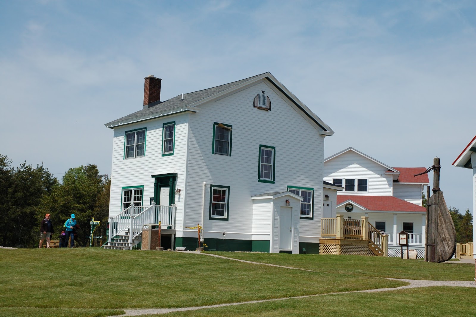
up to Whitefish Point to see the Whitefish Point Lighthouse and Coast Guard Station (Est. 1849) and visit the Great Lakes Shipwreck Museum.  We took a tour of the lighthouse, visited the museum, lifeboat station (boathouse), and the Keepers Quarters.  There is a replica of the Edmund Fitzgerald made from over 15,000 lego blocks.  It was a high school project that took over 9 years to build.  The EM sank some 17 miles from White Fish Point on November 10, 1975, with a loss of the entire 29 person crew.  The ship lies twisted and broken at a depth of 535 feet.  In the summer of 1995, the Great Lakes Shipwreck Historical Society together with families of the Fitzgerald’s crew, Canadian Navy and the National Geographic Society raised the bell to honor the 29 men lost.  Today the ship’s bell can be seen in the Museum Gallery.  A new bell with the names of the 29 men was placed back on the ship as a memorial to those lost.  There is also the Whitefish Point Unit of Seney National Wildlife Refuge for migrating birds.  We didn’t have time to stroll through the refuge.


 Edmund Fitzgerald - 15,000 lego blocks
 

We headed to Tahquamenon Falls SP to check in and view the upper falls.  We stopped at the Tahquamenon Brewery inside the park for a couple of whitefish sandwiches.  I had their Pale Ale and Susan had root beer.  We sat out on the deck with Sarah laying at our feet having lunch and listening to live music.  When took the trail to the Upper falls.  This may have been the prettiest of the falls that we saw.  We opted not to visit the lower falls as our campground was located on the Tahquamenon River and was a bit of a drive.  I also had a fishing license for the day and wanted to get some fishing in.  Storms moved through the area with thunder and lightning so my fishing was delayed until 7pm and then for only an hour or so.  Again I didn’t get a nibble.  We moved the table under the awning and dinner consisted of appetizers as it was getting late.


Tahquamenon River & Upper Falls
Tahquamenon River from our campsite


June 11th
Up early and on the road to Muskegon, MI for our last night before home.  We saw a sign for the scenic bye way along Whitefish Bay.  This was a good choice as we drove along the coast.  Up in a dead tree was a bald eagle.  I turned around to get a photo and the eagle had left its perch.  That would have been a great photo.  Oh well, at least we got to see our second bald eagle on this trip. 


We stopped at the Point Iroquois Lighthouse.  It was pretty but very overcast.  Our drive took us through the Hiawatha National Forest and Bay Mills Indian Reservation and we stopped the Dancing Crane Coffee House for coffee and a pastie as they call pastries. 
The fog would follow us the rest of the way to Mackinac.  We stopped at the point before crossing, but the fog was so thick you couldn’t see the bridge.  We saw three pairs of geese with their goslings.   


We crossed the Mackinac Bridge around 10:30 a.m. and the fog was lifting on the West side of the bridge and plenty of blue sky, but the bridge was covered in fog as we drove across.  We stopped at Colonial Michilmackinac and Mackinaw City and visited the lighthouse and grounds, just as the fog unveiled the bridge.  This was a great photo.


We then head for Michigan Highway M119, “Scenic Heritage Route” to drive along the coast of Lake Michigan through the famous “Tunnel of Trees”.  Twenty miles of twisting and narrow road leading through the beautiful landscape. 


I had planned on taking a combination of US 31 and M22 along the Eastern Shore of Lake Michigan down to Muskegon, but when I set the GPS it gave us an arrival time of 4:30 p.m. and the planned route would have added 2+ hours.  We needed to stop for lunch and took Highway 131 South.  We had driven half of the planned route last summer when we left Sleeping Bear Dunes National Lakeshore.  We passed Boyne Mountain Ski Resort (rode the chairlift up to the top and walked down the slope through the beautiful flowers), a place I visited with my family 56 years ago during a summer vacation, a trip that took us across the Mackinac bridge up to the locks at Sault Ste Marie.  These were very distant memories, but fun to think back to a time spent with one’s family driving along in the wood paneled family station wagon (with rear facing seat) .  Along Highway 131 we pasted a sign that said halfway between the Equator and North Pole, 45th Parallel. 

We arrived at Muskegon SP around 5 p.m. and checked in.  The campground was packed.  Our site had trees on two sides which made it a little quieter than the rest of the park and we didn’t have anyone on the other side.  We took several walks down to Lake Michigan and again were treated with a beautiful sunset. 


 Sunset over Lake Michigan


Muskegon Lighthouse on left and harbor entrance beacon on right


June 12th
We were up early and on the road for home.  We stopped at a pancake house for breakfast on our way out of Muskegon.  We arrived home around 1 p.m. Our trip covered 10 days, 9 nights, 2,144 miles, 4 state parks, 1 National Lakeshore, and some of the most beautiful parts of our country.

2016 - Wisconsin & Michigan's Upper Peninsula - Part 2


June 7th  (Happy 41st Anniversary)
We again got up early and headed for Munising, MI and Pictured Rocks National Lakeshore.   One of many deer spotted during our trip.  This was along South Boundary Road leaving Porcupine Mountain.


We arrive late morning and picked out a campsite at Twelvemile Beach Campground, on the bluff overlooking Lake Superior.  The view was great and the 20 foot bluff was easy to navigate to the beach or the staircase which was an easy walk from our campsite.  It was windy and cold, which kept the Sable flies at bay.  We dropped our stuff off at our site and headed into Grand Marais for lunch and re-supply.  Stopped at the Lake Superior Brewing Company / Dunes Saloon for a burger and brew.  Little did we know that we would  return for lunch or early dinner each day that we were there.   On the way back to camp we stopped at Log Slide Overlook.  This is where they dropped the logs down the chute into Lake Superior where they were loaded aboard ships heading for the mill.  This was a very steep slope to the beach, so we hiked along the edges.  The sunset each evening was truly amazing.


 Log Slide Overlook
 Grand Sable Dunes

 Au Sable Lighthouse

 Sunset from our campsite overlooking Lake Superior


 Views from our campsite


Michigan Highway H58 through Pictured Rocks N.L.


 Lake Superior Brewing Co. & Dunes Saloon.  I had a burger and Susan the White Fish Tacos

 Not sure whether this was a woodpecker or how this occurred

June 8th
Got up early and took the dog for a walk on the beach and then lowered the top and headed back into Munising along Highway H58, a beautiful road lined with White birch, red and silver maples, oak and  pines.  We had our daily sightings of white tail deer, in the road, along the side of the road, or crossing in front of us.  Today we would also see two Sand Hill Cranes along the side of the road and a turtle crossing the road.  We stopped first at the Interagency Visitors Center (National Park Service & U.S. Forest Service).  We went to the trailhead for Munising Falls and they had the trail closed for repairs.  Guessing the trail was damaged by the heavy rain as we observed other hiking trails to be washed out and muddy. 

After the attempt to see Munising Falls we drove out to Sand Point to the National Lakeshore headquarters, which was formerly the Munising United States Coast Guard Station.  The station was built in 1932 for a cost of $12,230.  The station closed in 1960 and donated to Pictured Rocks National Lakeshore in 1966, the year PRNL was established.  We got to see the small museum and motor surf boat.  We walked down to the beach and viewed the sandstone cliffs along the shore of Grand Island and the main coastline.

 PRNL Headquarters - Formerly Munising US Coast Guard Station
 Grand Island


From there we headed to Miners Falls and hiked to the falls from the trailhead.  This was another beautiful waterfall.  We stopped again for lunch at Lake Superior Brewing Company and then headed to Sable Falls.  The hike was short and the results were again picturesque.  The trail to Grand Sable Dunes was closed.  The posted signs said the dunes were closed due to unstable sand.  We had gotten to view the coastline of the Dunes the day before from the Log Slide.

We headed to Hurricane River to walk along the North County National Scenic Trail to view the Au Sable Light Station.  Unfortunately pets aren’t allowed on this trail and the 3.4 mile round trip hike and viewing of the Lighthouse was too long to leave the dog in the truck during the heat of the day.  The North County National Scenic Trail extends between new York and North Dakota.  We walked down to the Hurricane River mouth where it flows into Lake Superior.  Another great place.  I decided to get a fishing license and return the next day.


 Miner's Falls
 Lake Superior


 Miner's Castle
 Sable Falls


Mouth of Hurricane River


June 9th

We got up early and headed back east on Highway H58 to grab breakfast at the Bear Trap.  I opted for the Northern Omelet, measuring 12” X 8”, and I ate the entire thing.  Sorry everyone, in my shock and excitement I forgot to take a picture.  There was a saying on the wall:  “May your pockets be heavy and your heart be light, may good luck pursue you each morning and night”.  After a more than hearty breakfast we drove to the trail head for Mosquito and Chapel Falls.  The road was being repaired and there were numerous holes and stretches of soft sand, so 4-wheel drive was needed.  We opted to take the 2.2 mile roundtrip hike to Mosquito Falls first, but only got a third of a mile in when the trail became washed out and muddy (major repairs needed).  We turned around and took the Chapel Falls trail, approximately 3.4 mile round trip hike.  These falls were also very beautiful.  We went back to the Hurricane River and I fished along the shore and then the mouth of the river.  No luck.  Saw some Suckers spawning in the rocks and they were the only fish I saw.  Another person fishing with live bait caught some Lake Superior white fish.  We picked up some firewood for a great evening along the shore.

 Chapel Falls

 Sunset from our campsite

 Enjoying a night around the campfire


We visited with Larry & Wendy, a couple from California with a 2013 Northern Lite pop-up camper.  They had left California mid-April to attend a nieces wedding in New York and were working their way back west.  Also met another couple from Junction, TX with a Little Guy Teardrop Trailer.  Tonight was another beautiful sunset.

The one thing we really wanted to see was Pictured Rocks from a boat on the lake.  The boat trip was 2-1/2 hours and we couldn't leave the dog in the truck.  We found out from Larry and Wendy that they have a kennel and will board your pet for free while you take the cruise.   We were a bit disappointed we didn't look more thoroughly into this, but will make another trip up there for sure.