Inreach Map (Password - Palo Duro) https://share.garmin.com/JohnDorrer
This trip is
different from all the others. I
wouldn’t have intended it to be that way, but it is what it is.
This trip is solo, and the first time without my bride of
close to 43 years. I needed to visit my
ailing mother who has been in and out of the hospital after getting the flu
virus. Three weeks ago we visited in the
hospital in Dallas and now I’m back to spend a couple of days at her assisted
living place. Susan couldn’t take any
more time off. I also left our loyal
camping lab at home with her.
I left Saturday April 14th at 8:00am. I decided to drive to Dallas the entire way
off the interstate and I don’t intend on traveling on the interstate until the
camping portion of the trip is over on 4/22/18.
I wasn’t in a hurry and driving through Indiana farm fields and forests
was a slow paced way to see and enjoy the drive. In Indiana I crossed the White River which
was over its banks. As I crossed into
Illinois over the Wabash River, again the river was over its banks. It was the same for the Little Wabash
River. I drove south to the southern tip
of Illinois, passing through Cairo, Illinois to, a town decayed beyond the
possibility of any hope. I crossed the
swollen Mississippi River on a long 2 lane bridge. Not many of those left in the US, replaced by
the interstate bridges.
I drove to just outside Poplar Bluff, MO. I stayed at an Army Corp Of Engineers
campground at Wappapello Lake. It was
one of the nicest campgrounds I’ve stayed at.
I ended up making a sandwich and just kicking back in the camper. It would get down to the 30’s that night so
sitting outside was a no go. It was
different being alone. I read and tried
to look for the positive things going solo.
First, no butt bumping in the aisle, no waiting an hour while my wife did
her make-up, and not getting yelled at when I stepped on a frog. This trip has given me a great opportunity to
enjoy the back roads of our country, much the same as we did driving to Florida
in the 50’s and early 60’s.

Redman East Campground

Prior to the start of the trip I did some research on the
“Trail of Tears”. My route took me
southwest through a small town of Batesville, AR. The route took me along the Heritage Trail
for the Trail of Tears and the Civil War.
I spent a half hour driving around Batesville. And in the historic
district found Civil War Monument
dedicated to the Confederacy. There were
several battles between the Union and
Confederates. The town was occupied the
Union and Confederate Armies at different times throughout the war. The Trail of Tears passed through Batesville,
and head up highway 69 toward the Northwest after crossing the White
River outside Batesville. I drove toward
my next destination of Hot Springs, AR I
followed the Heritage Civil War Trail all the way to Hot Springs.
Following the election of Andrew Jackson in 1828, long held
desires for the lands of the Cherokee, Choctaw, Creek, Chickasaw and Seminole
Indians came to fruition with the federal Indian Removal Act of 1830. This act allowed the forcible removal of the
five tribes to new lands in the Indian Territory (modern -day Oklahoma).
All five tribes passed through Arkansas, and many of the territory’s
most prominent figures made substantial fortunes from removal. The Choctaw were the first to agree to a
removal treaty, emigrating in three official waves in 1831, 1832, and 1833. There was lots of fraud and many deaths for
all tribes as they moved west.


Cherokee leaders fought removal in the courts and in
Congress, contesting Georgia Laws and an unauthorized 1835 Treaty. Unable to elude expulsion, the Cherokee
Nation organized its own removal in 1838-390. Hundreds of members of each of
the tribes died of hardship and disease on the long trek to Indian Territory,
and many more died of hardship in their new land. The removal of the southeastern tribes is memorialized as the “Trail of
Tears.”
There were two Cherokee routes, The Bell Route and the John
Benge Route. John Benge, a Cherokee
Leader led a group from Pitman on the Missouri/Arkansas border, with one of the
two routs passing through Bateville and Fayetteville, AR. Their journey ended at Mrs. Webber’s farm
near present-day Stillwater, OK on January 17, 1839.
I arrived in Hot Springs, AR around 1:30pm on Sunday. After selecting a site, I drove downtown and
hit the visitors center and walked along bath house row. I then drove up into the mountains and went
up in the observation tower. Beautiful
view but winds over 50-60 miles per hour. I will return with Susan, there is a lot to see and do. I want to visit a bath house and soak in the
hot spring water. Also, There is a walking/motor tour of 26 markers
related to baseball spring training that used to be held in Hot Springs. That is how the namew spring training was
derived. Over 45 percent of the National
Baseball Hall-of-Fame members participated in spring training in Hot Springs.

Observation Tower Views


Bath House Row


My campsite was wonderful.
The National Park Campground is located at the base of the
mountain. The sites are paved. It is first come first serve.

I left early for Dallas.
Approximately one hour south of Hot Springs, AR I spotted a mountain
lion crossing the road in front of me.
It was a large one. When I did
get to Dallas I contacted the Arkansas Department of Natural Resources,
wildlife division and they confirmed numerous sittings of mountain lions
throughout the state.
Mr trip to Dallas was to visit my ailing mother who
contracted the flue in early February.
She has been in and out of the hospital.
When the elderly spend time in the hospital, they lose most of their muscle
tone. Combined with a UTI which makes you appear to have dementia, things were
in a dangerous state. It is all
downhill. My younger sister spent the
previous week there so I got to visit with her as well has my older sister (the
middle one). It had been almost 7 years
since we were all together. It is sad,
but the way things go for the elderly.
Hospitals just don’t offer physical therapy and the elderly just lay in
their beds. I left early Wednesday
morning for the Texas Panhandle.


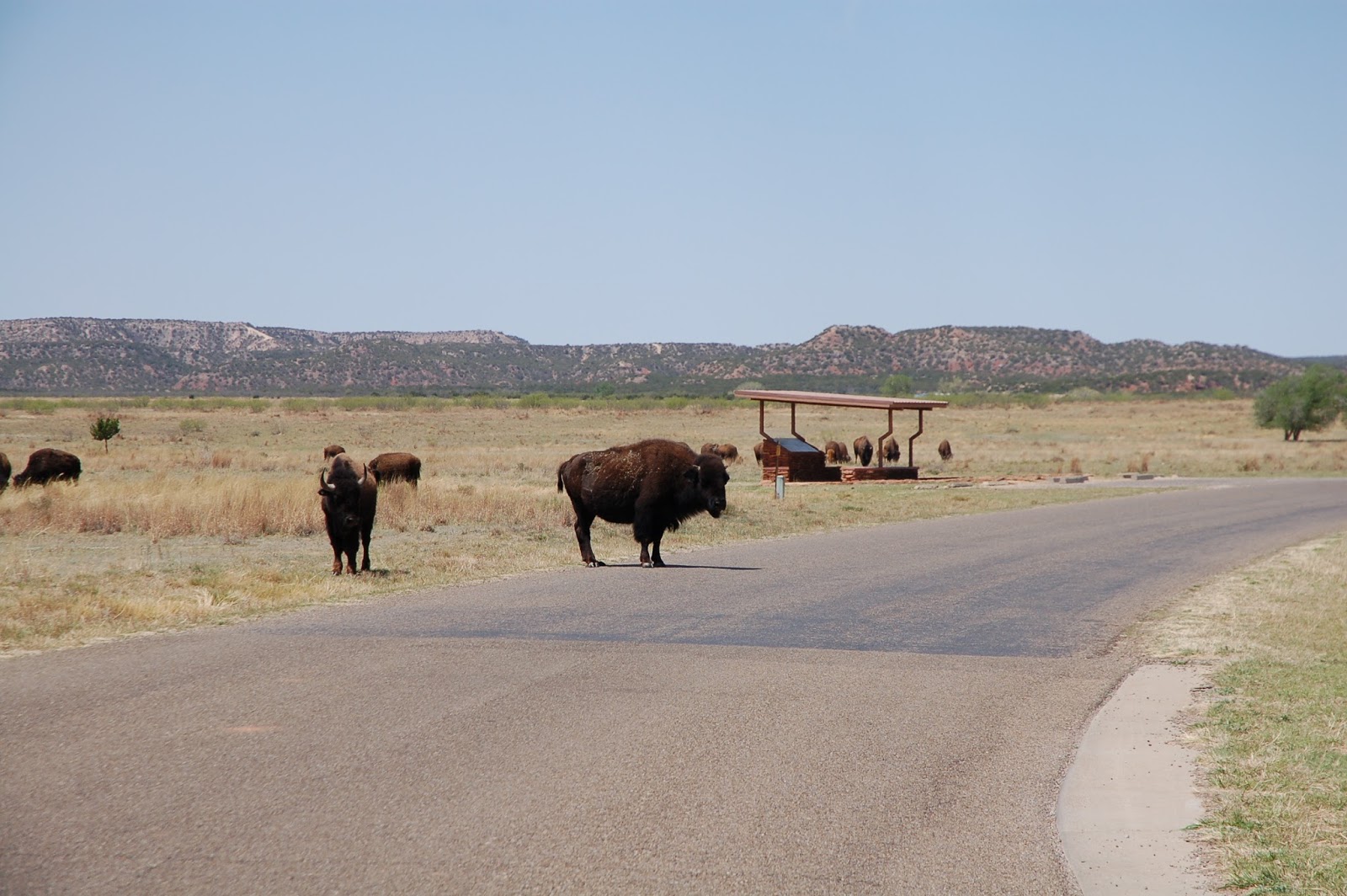
I arrived at Caprock Canyon State Park around 12:30pm. I paid for my site, dropped somethings off
and then started exploring the park. It
is beautiful. I drove the canyon loop
road. This park is a bison open range
park. They wonder through the
campgrounds. My neighbor has a Northstar
pop-up and he really likes the camper. Today we met out on the trail. I rode the canyon rim trail and stopped to
get great canyon shots. I lifted my bike up over a gate and rode and walked
until I got to paved road. The dirt road
was like sand and nearly impossible to ride in.
I entered the park and had to hold up along the road as bison were
stopped in the center of the road. I had to wait until someone in a truck ran
interference. The loop I did was over 8
miles through beautiful land. Later when
I went for another ride I discovered my rear tire was flat. I didn’t have a patch kit, and that will be
the end of my bike riding until I get home and get it fixed. Green slim will be in the tires moving
forward.


Turkey, Texas - Tour Bus for Bob Wills and the
Texas Playboys


Briscoe County Jail


I left for Palo Duro Canyon State Park Friday morning around
8am and arrived before noon. I stopped
by the visitors center after getting my campsite. On the way down into the canyon I stopped for
a burger at the Trading Post and to pick-up some ice. Roger Redmond and his wife Susan arrived
around 3pm. Their site was about 5 miles
back up the road, so we agreed that my pull through should be FWC City for the
night. Dwight Buckles arrived around 4pm
to drop off my new off road trailer.
After hooking it up we stood around and drank a few beers and talked
about Rogers Texas Borders trip that he did with fellow Texas Overland
folks.


I grilled bacon wrapped filets and squash for Roger and
Susan. The storm started moving in so we
had dinner in my camper and talked until about 9:30pm when they headed for
their camper. We had heavy rain that started around 7:30pm and lasted into the
morning. In the morning I cooked up bacon and blueberry
pancakes. We sat out at the picnic
table. Dwight showed up about 8:15am
with Roger’s trailer. Dwight made some
modifications to Roger’s trailer after he had run over 6,000 miles over rough
roads on the Texas Backroads trip. They
all left shortly after we had a picture taken.
Palo Duro Canyon is a canyon system of the Caprock
Escarpment located in the Texas Panhandle.
The canyon is 120 miles long with an average width of 6 miles. It is the second largest canyon in the United
States. It is 820 to 1000 feet in
depth. Palo Duro is called the “Grand
Canyon of Texas”. The makeup of the rock
is found in “The Quartermaster Formation”, Tecovas Formation, multi colored
shale, siltstone, and sandstone, Trujillo Formation – sandstone, and the
Ogallala Formation – sandstone, siltstone, conglomerate eroded from a late
Cenozoic Uplift of the Rocky Mountains.
Human Habitation dates back 10,000 to 15,000 years.
I went for a hike and climbed up to the cave. The wet red clay was hard climbing with caked
hiking boots. Also near the cave there was a layer if white satin-spar gypsum,
which was wet and also made the climbing hard.
Several young boys climbed to the canyon rim and entered the cave from
above, appearing on a ledge 15’ above me.
If only I was 30 years younger. It
started raining again so I started to get some of the packing done so I’m ready
to leave in the morning.


Roger Redmond, JD, and Dwight Buckles of Trekmate Mobile Adventure Units

Roger and his wife Susan getting ready to leave


Our new Trekmate Off-Road Trailer

Roadrunners


Cottontail


The white layer is gypsum


I left around 7am Sunday morning and headed for home. I drove through Oklahoma City and Tulsa along
I-40 and then I-44. There were Trail of
Tears signs that extended from the Oklahoma border Northeast along I-44 to St.
James, Mo. This was along the old Route
66. There are actual places remaining of
Route 66 but most appears to be complete interstate highway. There were signs with all types of tourist
traps. It might be fun to travel this
route someday so research will be in order. I drove to Lebanon, MO and stayed
at Bennett Springs State Park, about 12 miles North of Lebanon. It rained most of the way along I-44 and
while I was getting the camper set-up for the night. I made dinner inside. There is a river that runs through the park
and it looks like some trout fishing As
I departed Monday morning I saw a beautiful water fall. We might have to explore this park again.
I arrived home around 3pm on Monday. It was a fun trip, but I wish my co-pilot was
with me. Both Caprock Canyon SP and Palo
Duro Canyon SP were beautiful. There is
so much more to see on our next trip.


